Equipment Title
Specifications
Description
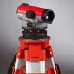
AUTOMATIC LEVEL
Stand & 4 Meter Staff
Magnification : 24X
Standard Deviation : ± 1.5 mm / km double run
Compensator working range : ± 15’ Magnetic damping compensator
The ease of use of Auto level has made it popular among surveyors.
PLANE TABLE
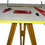
Plane Table 600 mm x 750 mm x 22 mm
Plumbing fork
Plumb bob, Through compass
Alidade, Spirit level
Used in surveying and related disciplines to provide a solid and level surface on which to make field drawings, charts and maps
PRISMATIC COMPASS
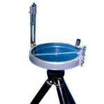
Prismatic Compass 125 mm Dia. With Aluminium Tripod
Used to find out the bearing of the traversing and included angles between them, waypoints and direction.
TOTAL STATION
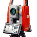
Total Station
Aluminium tripods
A Total station is an electronic/optical instrument used in modern surveying for leveling and angular measurement.
STANDARD THEODOLITE
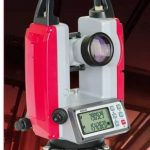
Standard Vernier Theodolite Incorporating high resolution optical axis
Erect image with the help of eyepiece
Optical plummet embedded in alidade rotating through 360° Kinematic Steel axis with ball bearing 20 Sec Least Count.
Used for measuring angles both horizontally and vertically
REMOTE SENSING & GIS LAB